
Wow, how have six weeks passed since I was in East Malaysia heading up Mount Kinabalu? I have been to West (Peninsular) Malaysia many times, but have never been to East Malaysia. There were numerous little logistical challenges with my trip to East Malaysia. Firstly, Sabah Park authority requires all climbers to have permits and a guide. The fact that there are only 100 permits handed out per day, and that one has to apply for a permit months in advance concerned me. I didn’t want to end up being part of a massive group, so I decided to go for the option of using Mountain Torq. Their key differentiator is that they own the world’s highest via ferrata, located on the higher slopes of the mountain.
I flew into Kota Kinabalu (Kinabalu city) on the Sunday from Kuala Lumpur, and stayed with friends. Early the next morning, we were picked up in a mini-bus and I slept across a couple of seats for most of the 2 hour journey as the mini-bus driver defied death with his driving antics.
Opposite the park entrance we stopped at a local eatery to pick up a simple lunch, then entered the park and registered. We had to provide our legal documents and were issued with individual passes on lanyards. We were also introduced to our (mandatory) park guide. The guides are local to the area and all appeared friendly, but they are not necessarily mountain guides in the IFMGA sense. On the bright side the route is not technical, so they are there mainly to keep pace and to answer all of my inane questions about the mountain and surrounding areas.
From the park offices there was a couple of mile drive to the head of the trail in a smaller car. Depending on which company you book with, this transport may not be available for free. The alternative is to walk it, but the road is narrow with no pavement, and vehicles careened round corners haphazardly. Even on the descent I opted against walking this stretch. At the trail head, there is a final opportunity to purchase (rather unnecessary) snacks. You have to pass a control point as you enter, and from here the trek up the mountain truly begins!
The walk up was intentionally slow to aid acclimatisation. We were lucky with the weather on the ascent, as the rain held off. Trainers are sufficient for this walk; I wore rock approach shoes all the way to the summit. I wore Patagonia trekking trousers which zip off into shorts, plus a short-sleeved top. A hydration bladder kept me hydrated, although there were six or seven water stations along the way, so one would be OK with a smaller water container. I didn’t drink from them and can’t vouch for how safe that water is to drink! On the way up there are also basic toilet facilities, which were kept in good condition (bring your own toilet paper if required).
Onto the more interesting aspect – the views!
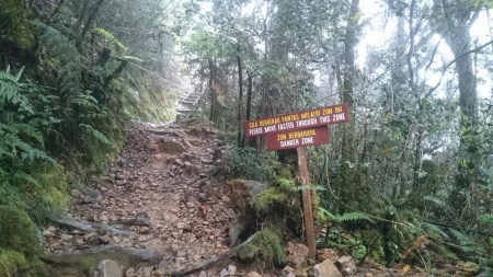
There remains the possibility of rockfall, particularly after heavy rain
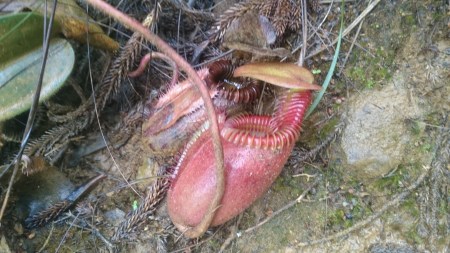
The carnivorous nepenthes plant, also know as the tropical pitcher plant
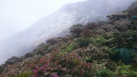
Higher up on day one, the flora and fauna becomes sub-alpine
The walk up from the trial head to the huts takes 4 to 6 hours, rising 1400 metres in the process. As you rise, the rainforest slowly gives way to a sub-alpine environment. The huts are located just below a band of rock that continues all the way to the summit. If you are with Moutnain Torq, once you reach the hut, your park guide leaves you in the capable hands of the staff in the hut.
The accommodation was perfectly respectable by international standards, but this will depend on which company you book through, as different companies have different huts. Moutain Torq’s hut is Pendant Hut and is located high in the camp. Food, sleep, shower and toilet facilities were all spot on – though dinner is served in a separate restaurant hut, which offers a buffet dinner, as well as selling snacks and even beers (at an eye-watering RM24 per can of domestic lager). Mountain Torq clients are also taught (indoors) how the following day’s via ferrata system works. It’s only a few years old, and is cleverly designed so sections spanning hundreds of metres can be covered without having to disconnect from the safety system.
Depending on your progress, your mountain guide will specify a start time of 2 or 3am for summit day, and will meet you at the hut in the morning. The start time is, however, predicated by the park authorities permitting mountaineering activity on the high mountain that day. Little gate locked = no one goes any higher! Fortunately, it didn’t rain too heavily overnight so the little gate was unlocked, and everyone from our hut proceeded up through a section of forest, before the path expanded out onto a rock escarpment. A white nylon rope marked the route. I had had a chat with my mountain guide who let me bimble off into the darkness on my own ahead of the rest of the group.
Past a final manned check point, the mountain really opened up. I turned my headtorch off and let my eyes adjust to the moonlight. For me, this was the highlight of the trip. Alone, high on the mountain, walking up a rock slab, the twinkling of stars above and city lights far down below. I fell into a steady rhythm, taking in the views, and reminiscing about all my achievements over 2016.
I bounced up the final steeper section, and enjoyed the summit all to myself for a quarter hour (OK, there was a rodent who I christened Mr Rat who was also there). I watched the steady stream of headlights below me zig-zagging their way up the mountain. 75 minutes later, the sun came up and lit our way down.
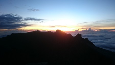
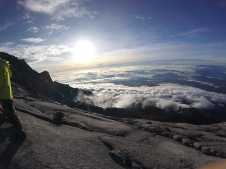
I was rewarded with the view of sunrise from the summit
Further down, Moutain Torq clients regrouped and started a full morning of via ferrata activities. The views were great, and we moved in groups of twos and threes (plus a Mountain Torq guide per group). We did the “Low’s Peak” circuit, which takes several hours at a slow pace.
Wide angle view from near the summit, getting ready for via ferrata. Barren rock face at this height.
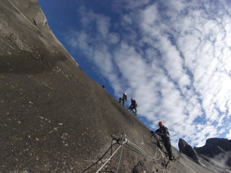
The via ferrata can be quite exposed, but the views are worth it!
After a lunch at Pendant Hut, I started my descent back down the mountain. I had agreed with the park guide that I could go down on my own. The monsoon rain came in and I ran down faster to keep warm, back through the sub-alpine zones and through the rainforest path, before finally reaching Timpohon Gate again and hitching a lift to the park entrance.
If you’re ever planning on visiting East Malaysia, the mountain is worth a visit!
Keep climbing
GeekintheHills
